
In Part One, we explored how digital technology has transformed Silk Road archaeology through the digitization of archaeological sites and the digital archiving of artefacts. Building upon these foundations, Part Two delves deeper into the digital reconstruction of artefacts and the use of GIS mapping to uncover the intricate networks of trade and exchange that defined the Silk Road.
Artefact reconstruction
Digital technologies have been actively applied in artefact reconstructions, such as the virtual restoration of mural paintings from the Kizil Caves, Kucha, Xinjiang Autonomous Region of China. Due to the many archaeological expeditions that took place in the early 20th century, a lot of mural paintings from Buddhist rock-cut temple sites were removed. Taking the Kizil Caves as an example, the mural paintings were scattered to different parts of the world, including France, Germany, Russia, Japan, the UK and the US. Hence, studying these scattered mural paintings presents a formidable challenge to scholars. It was only in the last decade that Ms Zhao Li, a scholar from the Kucha Research Institute, was able to digitally restore a large portion of these mural paintings from Kizil. With years travelling abroad and visiting different museums and archives, she was able to access these mural fragments and connect them digitally. One can consider the extreme challenge and large scope of such a project, and it is exciting to see a publication showcasing this work was released in 2021 (克孜爾石窟壁畫復原研究).
To get a sense of the methods of reconstruction, the mural painting shown below is from the left wall of the Kizil Cave 207 (also known as the Painter’s Cave). The reconstruction was carried out on a currently “empty” wall (see photo below). Before we go any further, we should address the question – where did the mural painting go? A large number of mural fragments were removed by the third German Expedition (1905-1907) and were stored at the Ethnological Museum of Berlin, Germany. During the Second World War, Berlin was heavily bombed, resulting in many of these mural paintings suffering severe damage or were fundamentally lost.
On the empty wall, a reconstructed mural was created based on historical photographs (black-and-white sections) taken by the third German Expedition (1906). Fortunately, some mural fragments on the top row are still preserved at the Berlin Museum of Asian Art, hence they could be matched and merged with the historical photographs. In some cases, when photographs are not available, archaeological line drawings can be helpful. Considering the preservation status and the fragmented content, matching these mural fragments can be really challenging. In-depth analysis of these mural paintings, such as the recent work by Dr. Satomi Hiyama on Cave 207 have identified most of the themes and narratives embedded within these paintings, contributing significantly towards joining the pieces.
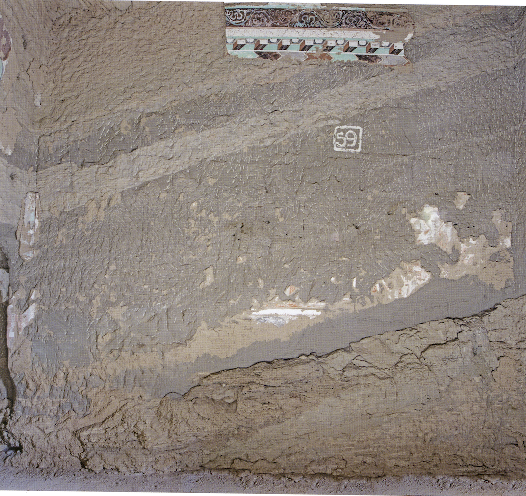
[Current left wall, Kizil Cave 207; Source: Zhao, 2021]

[Reconstructed left wall, Cave 207; Source: Zhao, 2021]
Moreover, the Xinjiang Kizil Cave Research Institute launched a digitisation project in 2021 (克孜尔石窟研究所馆藏文物数字化保护项目). It aims to construct 3D models of 80 artefacts housed at the institute and carry out the digital restoration of 160 pieces of artefact fragments, collected through several archaeological excavations since 1982. The outcome of the project will be showcased on an online platform, which will be released in due course. According to the project description, AI technology will be adapted to facilitate the mural conservation process and rock-cut temple surveys. The digitisation process of artefacts also allows the institute to create an updated and organised collection management system. Hence, they will be able to identify the movement of objects efficiently and reduce the workload of museum staff (for more, read their newsletter here).
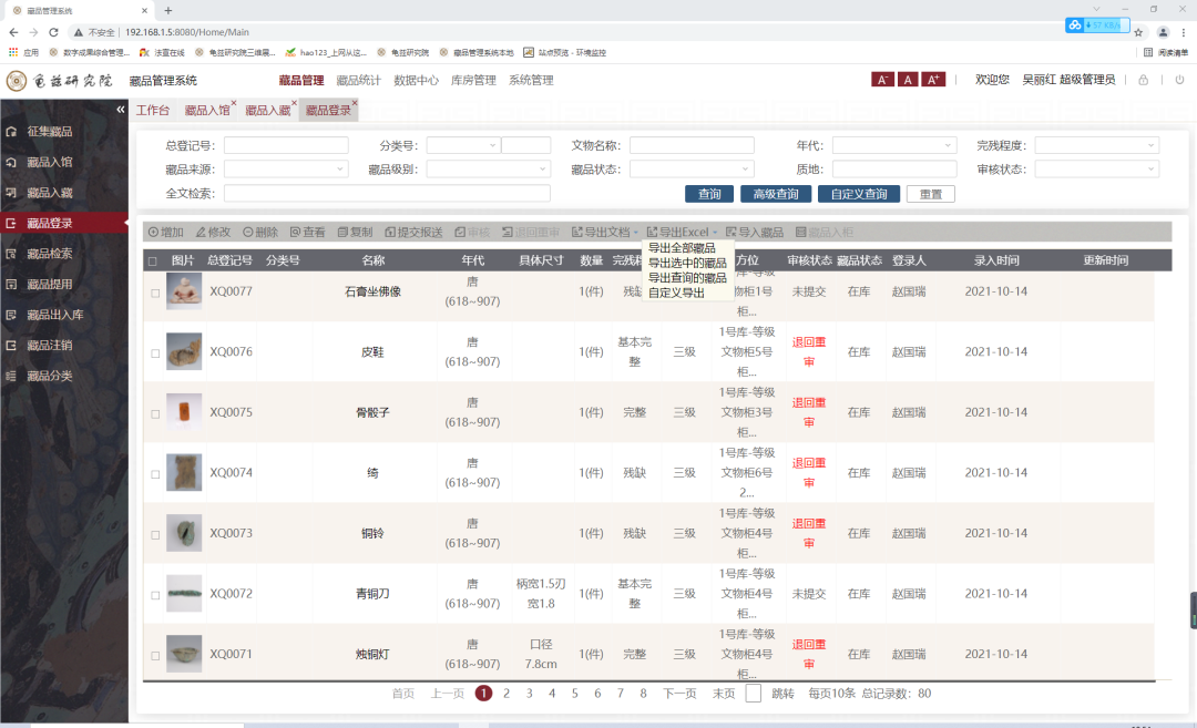
[Kucha Research Institute Collection Management system]
On the other hand, digital reconstruction is a helpful tool for artefact conservation. ‘Digital’ experiments have been conducted on fragments of the Qin terracotta armies, at the eastern section of the Silk Roads. Considering there are hundreds and thousands of terracotta army statues excavated from the Qin mausoleum and most of them are fragmented, these digitally constructed models help conservators to put the pieces back together efficiently. With the use of a 3D scanner, a workstation and 3D model creating software, one would be able to digitally revive a Qin soldier. The selected photos below (retrieved from a project website of the Northwest University) allow us to glimpse the working process:
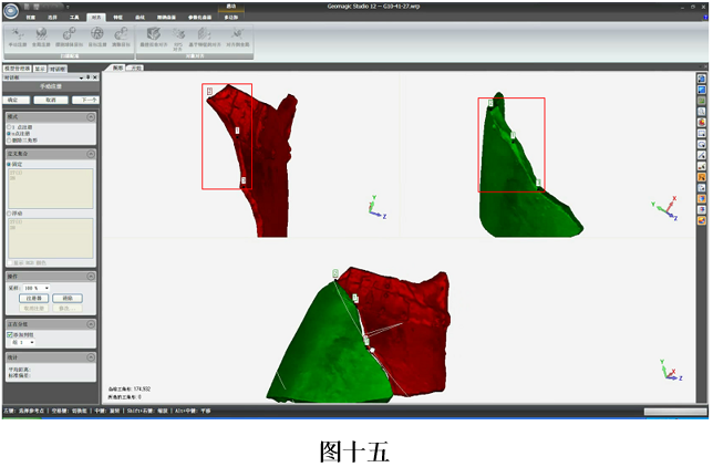
[After creating a model of the fragment, one can try to identify how these pieces match and then create a connected model]
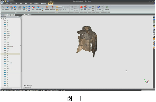
[After a consistent and repetitive process, a terracotta statue will eventually be formed]
In different archaeological sites, excavated artefacts often come in mixed pieces and a large amount. Archaeologists and conservators have to spend significant energy on matching them up and piecing them together in order to present how they should look historically. This complex and time-consuming work definitely hinders the popularisation of virtual restoration technology, as the above mentioned examples still had to be done manually. In the foreseeable future, machine-learning should be able to carry out this repetitive process, allowing fragments to be sorted effectively. This will support subsequent restorations, archaeological analysis, and even the exhibition processes.
GIS map trade routes
Geographical Information System (GIS) has emerged as a popular tool in archaeology in the recent decade. Projects such as the China Historical Information System (CHGIS), a joint project of Harvard University and Fudan University, have used GIS to present populated places and historical administrative units for the period of Chinese history between 222 BCE and 1911 CE.
Another example is the Silk Road Historical and Geography Information Open Platform (SRHGIS), which was established in 2017 and led by the scholar Zhang Ping. The project was supported by national funding and constructed to facilitate research on the history and geography of the ancient Silk Roads, focusing on the routes in China. It features temporal GIS, 3D virtual display, WebGIS, cloud GIS, spatial modelling, and analysis functions. The spatiotemporal data framework is based on the ArcGIS Geodatabase model, implemented with PostgreSQL and ArcSDE for storage and management. Its contents include temporal geographic data, imagery, elevation, and other data related to the Silk Road, as well as various thematic research databases.
The basic functions of the SRHGIS platform include historical place name query, map overlay and analysis, online map registration, 3D animation demonstration, and historical map database utilization. It includes information related to the natural environment, use of land, transport, commerce, religion, ethnicity, historical artefacts, archaeological sites, and the transmission of culture. Such approaches allow us to visualise historical sites, and to have a macroscopic and geographical view of historical events.

[SRHGIS platform main page]
Conclusion
In conclusion, the use of digital technologies in Silk Road archaeology has revolutionised the way researchers and the public engage with and understand our cultural heritage. This transformation has been unfolding over decades and is still actively evolving. From the digitization of sites to the reconstruction of artefacts, digital archiving, and GIS mapping, these applications have become essential tools in preserving and disseminating invaluable archaeological knowledge and historical insights.
As we all know, the ancient Silk Roads encompassed regions all the way ‘from the West to the East’. The “digital” Silk Roads are similarly expansive and can only be constructed and accessed through the continuous collaborative efforts of various cultural institutions, both present and future.

One thought on “The Age of Digital Technology: Silk Road Archaeological Sites and Artefacts (Part 2)”